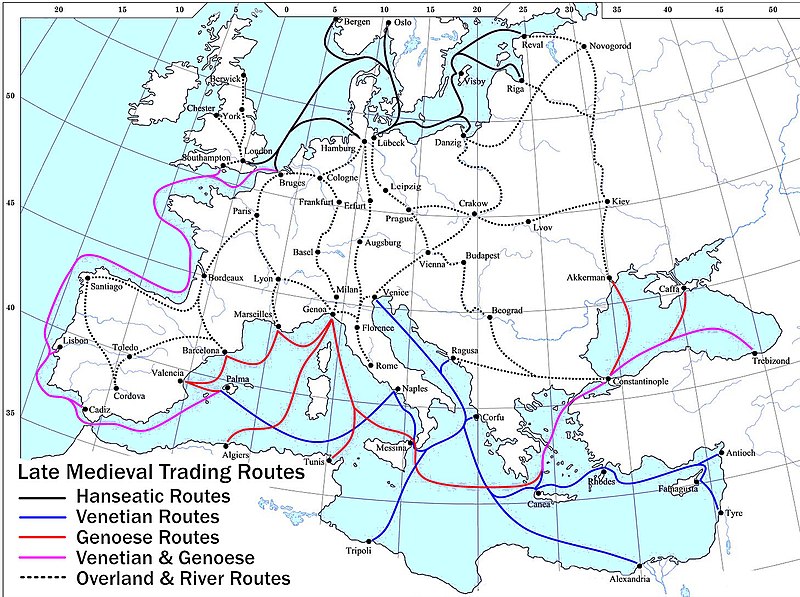
Файл:Late Medieval Trade Routes.jpg

Памер прагляду: 800 × 597 піксэлаў. Іншыя разрозьненьні: 320 × 239 піксэлаў | 640 × 478 піксэлаў | 1024 × 765 піксэлаў | 1280 × 956 піксэлаў | 1457 × 1088 піксэлаў.
Арыгінальны файл (1457 × 1088 піксэляў, памер файла: 372 кб, тып MIME: image/jpeg)
Гісторыя файла
Націсьніце на дату/час, каб паглядзець, як тады выглядаў файл.
| Дата і час | Мініятура | Памеры | Удзельнік | Камэнтар | |
|---|---|---|---|---|---|
| цяперашняя | 23:46, 18 траўня 2022 |  | 1457 × 1088 (372 кб) | Richard2s | Clearer key for map |
| 23:25, 23 студзеня 2011 |  | 853 × 544 (453 кб) | Micsha~commonswiki | Includes map key on the map | |
| 18:55, 28 сакавіка 2008 |  | 1817 × 1120 (487 кб) | Lampman | {{Information |Description=Map showing the main trade routes of late medieval Europe. The black lines show the routes of the Hanseatic League, the blue Venetian and the red Genoese routes. Purple lines are routes used by both the Venetians and the Genoese |
Выкарыстаньне файла
Наступная старонка выкарыстоўвае гэты файл:
Глябальнае выкарыстаньне файла
Гэты файл выкарыстоўваецца ў наступных вікі:
- Выкарыстаньне ў ar.wikipedia.org
- Выкарыстаньне ў bg.wikipedia.org
- Выкарыстаньне ў ca.wikipedia.org
- Выкарыстаньне ў da.wikipedia.org
- Выкарыстаньне ў el.wikipedia.org
- Выкарыстаньне ў en.wikipedia.org
- Выкарыстаньне ў es.wikipedia.org
- Выкарыстаньне ў et.wikipedia.org
- Выкарыстаньне ў fr.wikipedia.org
- Выкарыстаньне ў he.wikipedia.org
- Выкарыстаньне ў hy.wikipedia.org
- Выкарыстаньне ў it.wikipedia.org
- Выкарыстаньне ў ja.wikipedia.org
- Выкарыстаньне ў mk.wikipedia.org
- Выкарыстаньне ў nl.wikipedia.org
- Выкарыстаньне ў pl.wikipedia.org
- Выкарыстаньне ў pt.wikipedia.org
- Выкарыстаньне ў rm.wikipedia.org
- Выкарыстаньне ў sh.wikipedia.org
- Выкарыстаньне ў sl.wikipedia.org
- Выкарыстаньне ў sq.wikipedia.org
- Выкарыстаньне ў uk.wikipedia.org
Паказаць глябальнае выкарыстаньне гэтага файла.


