
Файл:WW2-Holocaust-ROstland.PNG
Няма вэрсіі зь лепшым разрозьненьнем.
WW2-Holocaust-ROstland.PNG (442 × 418 піксэляў, памер файла: 145 кб, тып MIME: image/png)
|
|
Гэты файл паходзіць зь Вікісховішча. Зьвесткі пра гэты файл зь яго старонкі апісаньня прыведзеныя ніжэй. Вікісховішча — сховішча вольных мэдыяфайлаў. Вы можаце дапамагчы. |
Апісаньне
| Апісаньне |
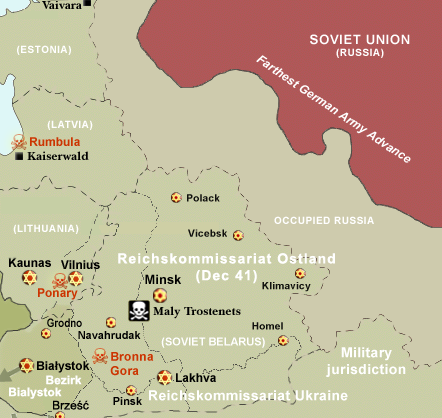
Map of the Holocaust in Reichskommissariat Ostland (Belarus and the Baltic States) during World War II, 1939-1945. This map shows all extermination camps (or death camps), most major concentration camps, labor camps, prison camps, ghettos, major deportation routes and major massacre sites. Notes: 1. Extermination camps were dedicated death camps, but all camps and ghettos took a toll of many, many lives. 2. Concentration camps include labor camps, prison camps & transit camps. 3. Not all camps & ghettos are shown. 4. Borders are at the height of Axis domination (1942). 5. Some regions have German designations (e.g. "Ostland"), with the present country name denoted in uppercase letters in parenthesis below the German designation (e.g. "(AUSTRIA)"). 6. Present (2007) borders are dotted. |
| Дата | (UTC) |
| Крыніца | |
| Аўтар | |
| Дазвол (Паўторнае выкарыстаньне гэтага файлу) |
CC, see below. The map is completely unrestricted for any Wikipedia/Wikimedia project. |
| Іншыя вэрсіі |
 Вытворныя творы ад гэтага файлу: WW2-Holocaust-Poland.PNGImage:WW2-Holocaust-Europe-2007Borders.png (present (2007) borders). If you have any opinions/suggestions, please contact me here on my talk page. |

|
Гэтая historical map выява мусіць быць створаная наноў у вэктарным фармаце SVG. У гэтым ёсьць некалькі плюсаў, глядзіце Commons:Media for cleanup для даведкі.
Калі SVG-файл дзесьці ўжо існуе, загрузіце яго. Пасьля загрузкі замяніце гэты шаблён на {{vector version available|новае імя файла.svg}}.
|
Ліцэнзія
I, Dennis Nilsson, уладальнік аўтарскіх правоў на гэтую працу, добраахвотна публікуе яе на ўмовах наступнай ліцэнзіі:
Гэты файл ліцэнзаваны згодна ўмоваў ліцэнзіі Creative Commons Attribution 3.0 Unported.
Пазначэньне аўтарства: I, Dennis Nilsson
- Вы можаце свабодна:
- дзяліцца – капіяваць, распаўсюджваць і перадаваць гэты твор
- ствараць вытворныя творы – адаптаваць твор
- Пры выкананьні наступных умоваў:
- пазначэньне аўтарства – Вы мусіце пазначыць аўтарства, падаць спасылку на ліцэнзію і пазначыць, ці былі зробленыя зьмены. Вы можаце зрабіць гэта любым разумным спосабам, але не такім чынам, каб склалася ўражаньне, што ліцэнзіят падтрымлівае вас ці выкарыстаньне вамі гэтага твору.
- derivative work: Piotr Konieczny aka Prokonsul Piotrus Talk
|Permission= |other_versions= }}
| Гэта рэтушаваная выява, якая была зьмененая ў лічбавай форме і адрозьніваецца ад арыгіналу. Зьмены: Belarus and Baltic States only. Арыгінальная выява: WW2-Holocaust-Europe.png.
|
Я, уладальнік аўтарскіх правоў на гэтую працу, добраахвотна публікую яе на ўмовах наступнай ліцэнзіі:
Гэты файл ліцэнзаваны згодна ўмоваў ліцэнзіі Creative Commons Attribution 3.0 Unported.
- Вы можаце свабодна:
- дзяліцца – капіяваць, распаўсюджваць і перадаваць гэты твор
- ствараць вытворныя творы – адаптаваць твор
- Пры выкананьні наступных умоваў:
- пазначэньне аўтарства – Вы мусіце пазначыць аўтарства, падаць спасылку на ліцэнзію і пазначыць, ці былі зробленыя зьмены. Вы можаце зрабіць гэта любым разумным спосабам, але не такім чынам, каб склалася ўражаньне, што ліцэнзіят падтрымлівае вас ці выкарыстаньне вамі гэтага твору.
Арыгінальны журнал загрузак
This image is a derivative work of the following images:
- File:WW2-Holocaust-Europe.png licensed with Cc-by-3.0
- 2007-12-20T03:41:38Z Dna-webmaster 1310x1090 (845818 Bytes) new version without "Axis cooperating" in legend
- 2007-12-20T02:00:30Z Dna-webmaster 1310x1090 (844034 Bytes) Now entire West Prussia and Wartheland is included in the Third Reich
- 2007-12-19T16:42:15Z Dna-webmaster 1310x1090 (847461 Bytes) still not Da Vinci, but errors have been corrected (Germany borders West/East), West & East Prussia borders/coloring and Poland General Government corrected borders.
- 2007-12-17T10:46:28Z Dna-webmaster 1310x1090 (844633 Bytes) new map with 1942 borders, not Da Vinci, but here it goes...
- 2007-10-19T13:32:25Z Dna-webmaster 1310x1090 (784727 Bytes) and another update
- 2007-10-19T12:21:52Z Dna-webmaster 1310x1090 (789383 Bytes) quick fix
- 2007-10-19T12:11:07Z Dna-webmaster 1310x1090 (789413 Bytes) {{Information |Description=Map of the Holocaust in Europe during World War II, 1939-1945. This map shows all extermination camps (or ''death camps''), most major concentration camps, work camps, prison camps, ghettos, major
Uploaded with derivativeFX' '
Гісторыя файла
Націсьніце на дату/час, каб паглядзець, як тады выглядаў файл.
| Дата і час | Мініятура | Памеры | Удзельнік | Камэнтар | |
|---|---|---|---|---|---|
| цяперашняя | 19:51, 29 ліпеня 2016 | | 442 × 418 (145 кб) | Poeticbent | file reloaded, cache promblems |
| 19:44, 29 ліпеня 2016 |  | 442 × 418 (145 кб) | Poeticbent | missing elements including locations | |
| 22:25, 5 верасьня 2013 |  | 442 × 418 (131 кб) | Poeticbent | most obvious error, Lithuania was never part of Reichskommissariat Ostland, neither was Bialystok, added names of major cities | |
| 21:44, 2 лістапада 2009 |  | 442 × 418 (90 кб) | Flying Saucer | Vaivara | |
| 22:32, 19 лютага 2009 |  | 442 × 418 (90 кб) | Piotrus | {{Information |Description=Map of the Holocaust in Reichskommissariat Ostland (Belarus and the Baltic States) during World War II, 1939-1945. <br> This map shows all extermination camps (or ''death camps''), most major concentration camps, labor camps, pr |
Выкарыстаньне файла
Наступная старонка выкарыстоўвае гэты файл:
Глябальнае выкарыстаньне файла
Гэты файл выкарыстоўваецца ў наступных вікі:
- Выкарыстаньне ў da.wikipedia.org
- Выкарыстаньне ў de.wikipedia.org
- Выкарыстаньне ў el.wikipedia.org
- Выкарыстаньне ў en.wikipedia.org
- Выкарыстаньне ў es.wikipedia.org
- Выкарыстаньне ў fa.wikipedia.org
- Выкарыстаньне ў fi.wikipedia.org
- Выкарыстаньне ў fr.wikipedia.org
- Выкарыстаньне ў fy.wikipedia.org
- Выкарыстаньне ў he.wikipedia.org
- Выкарыстаньне ў it.wikipedia.org
- Выкарыстаньне ў ja.wikipedia.org
- Выкарыстаньне ў mk.wikipedia.org
- Выкарыстаньне ў nl.wikipedia.org
- Выкарыстаньне ў no.wikipedia.org
- Выкарыстаньне ў pl.wikipedia.org
- Выкарыстаньне ў pt.wikipedia.org
- Выкарыстаньне ў ro.wikipedia.org
- Выкарыстаньне ў sr.wikipedia.org
- Выкарыстаньне ў sv.wikipedia.org
- Выкарыстаньне ў tr.wikipedia.org
- Выкарыстаньне ў vi.wikipedia.org
- Выкарыстаньне ў zh.wikipedia.org